Moderate atmospheric river targets Oregon and Washington this weekend, bringing rain, high snow levels, and runoff concerns
Wet weather returns after early-February warmth
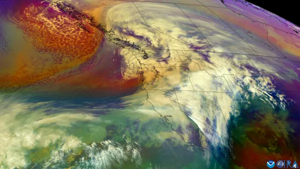
A moderate atmospheric river is forecast to reach the Pacific Northwest this weekend, shifting the region from a dry, unusually warm stretch to widespread rain and cooler temperatures. The event is expected to arrive Saturday and continue through Sunday, affecting the Oregon coast and the Willamette Valley, with impacts extending into Washington.
Rainfall totals: highest along the coast and Coast Range
Forecast guidance indicates valley locations may receive roughly 1 to 1.5 inches of rain by Sunday night, while the coast and the Coast Range could see about 2 to 3 inches over the same period. The wettest conditions are expected during Sunday, when steady rain is likely to persist for hours across many lowland communities.
Willamette Valley: around 1 to 1.5 inches through Sunday night.
Oregon coast and Coast Range: around 2 to 3 inches through Sunday night.
Cascades outlook: more rain than snow at first
While atmospheric rivers can deliver heavy mountain snow in colder setups, this event is expected to tap subtropical moisture that keeps snow levels elevated through much of Sunday. Higher freezing levels increase the likelihood that precipitation falls as rain at many Cascade elevations before transitioning toward snow later Sunday into early Monday.
Snow accumulations at resort elevations are projected to be modest compared with major midwinter snowstorms, with estimates generally in the range of several inches into Monday. The higher snow levels also raise the potential for increased melt of existing low- and mid-elevation snowpack during the warmest portion of the storm.
Why snowpack matters now
The timing is notable because the region is already experiencing exceptionally low snowpack for early February. As of February 1, Oregon reported record-low statewide snow water equivalent (SWE) in the SNOTEL record, with snow drought conditions widespread across both Oregon and Washington. A warm, dry January contributed to the deficit, and the current storm is not expected to be a major snow producer during its early phases due to elevated snow levels.
Low snowpack combined with rain can increase near-term runoff, while also limiting the longer-term water stored as mountain snow.
What to watch: runoff, localized flooding, and travel impacts
With the highest totals focused on the coast and Coast Range and rain falling at higher elevations than usual, residents should monitor for rapid rises on small streams, ponding on roads, and localized flooding in poor-drainage areas. In the Cascades, periods of rain and wet snow can create slushy passes and changing traction conditions as temperatures cool and snow levels lower late Sunday.
Conditions can vary sharply over short distances in the Pacific Northwest’s terrain, so travelers and outdoor recreationists should plan for changing weather and reduced visibility during the heaviest rain.